Chapter 3 · Part I · The plan
3
Walk access to parks
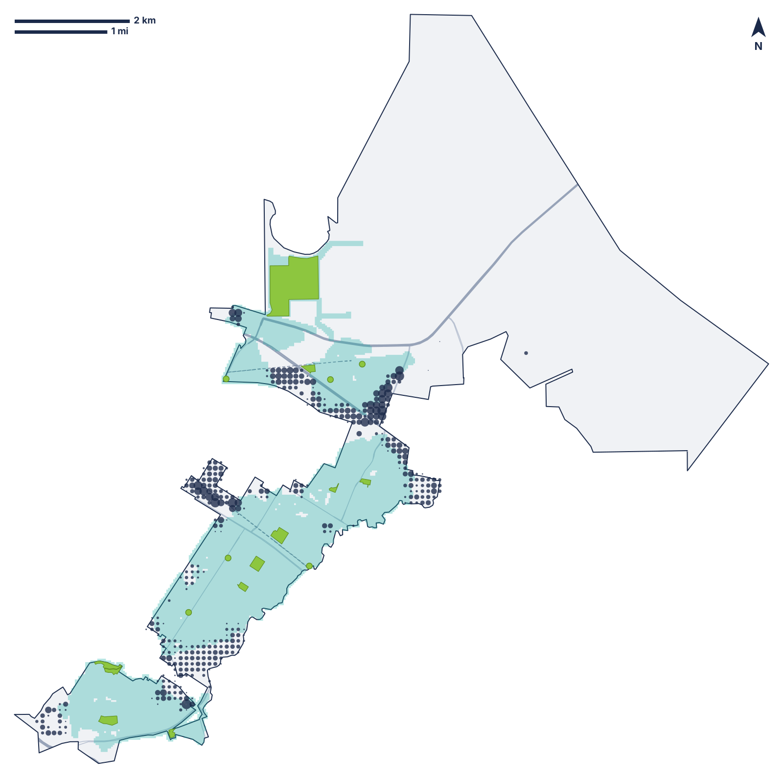 Teal: within a 10-minute walk of a City park. Dots: residents beyond it (bigger dot, more people).This plan's walk analysis · Census 2020 · City GIS · © OpenStreetMap · Public domain (Census) · City of Menlo Park GIS · ODbL 1.0
Figure 3.1Residents within a 10-minute walk of a park, citywide and by council districtWithin a 10-minute walk of a City parkAdded by shared school fields and other public parks
Citywide74.2% · 93.9% with school fields
District 172.0% · 95.1% with school fields
District 259.9% · 93.8% with school fields
District 371.8% · 91.3% with school fields
District 495.4% · 97.5% with school fields
District 571.0% · 92.0% with school fields
This plan's analysis: Walk-access analysis made for this plan: City GIS parks, 2020 Census, OpenStreetMap walking network (Nov. 16, 2026)
Residents within a 10-minute walk of a park, and acres of City parkland per 1,000 residents.
Figure 3.2District 1: residents outside a 10-minute walk of a City park, by Census block groupResidents outside a 10-minute walk of a City parkResidents within it
Carlton, Madera, Willow, Sevier, Pierce (6117.00-1)1,230 of 2,049
Block group 6117.00-20 of 2,001
Willow, Carlton, Madera (6117.00-3)300 of 1,693
Haven Ave. (6117.00-4)261 of 694
This plan's analysis: Walk-access analysis made for this plan: City GIS parks, 2020 Census, OpenStreetMap walking network (Nov. 16, 2026)
Figure 3.3The walk gaps in District 1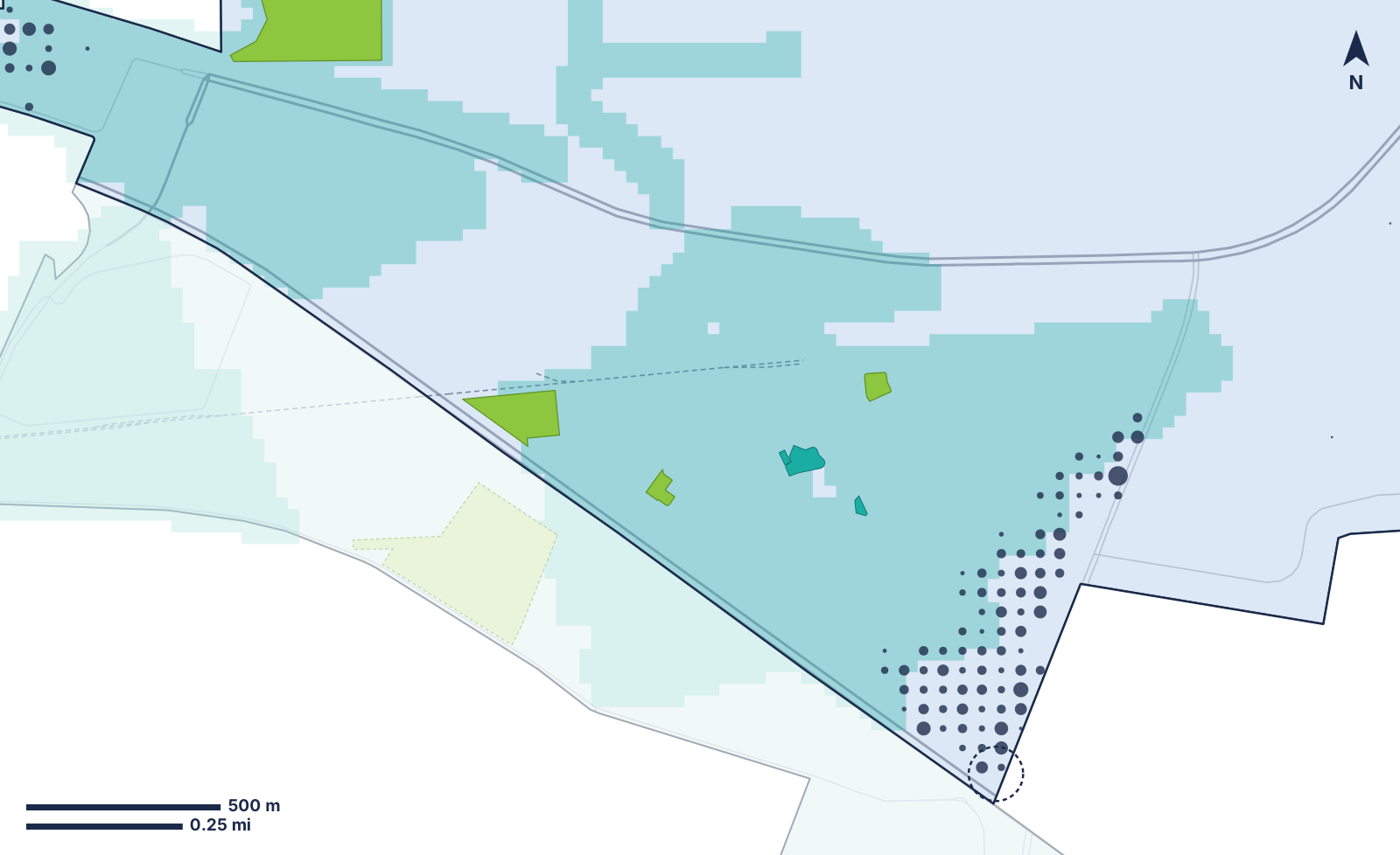
District 1: the biggest gap is near Carlton, Madera and Sevier; the ring marks Willow Road at Pierce Road.This plan's walk analysis · Census 2020 · City GIS · © OpenStreetMap · Public domain (Census) · City of Menlo Park GIS · ODbL 1.0
The City's standard: 5.0 acres per 1,000 residents (2019 plan)
Bedwell Bayfront Park’s 163 acres are in District 1; with them, District 1 has 26.4 acres per 1,000. This plan's analysis: Walk-access analysis made for this plan: City GIS parks, 2020 Census, OpenStreetMap walking network (Nov. 16, 2026) City record: City GIS: park outlines (Menlo_Park_Parks layer) (Nov. 16, 2026)
Figure 3.5Parkland per 1,000 residents as the housing plan’s homes are built, at today’s acresPlus the 1,153 homes permitted by 20256.14
Plus all 2,946 homes in the 2023-2031 plan5.46
The City's standard: 5.0
At 2.57 residents per new home City record: Staff Report 23-024-CC: adopting the 2023-2031 Housing Element, with its environmental findings and their ratio of 2.57 persons per household (Jan. 31, 2023), C-1.28 This plan's analysis: Walk-access analysis made for this plan: City GIS parks, 2020 Census, OpenStreetMap walking network (Nov. 16, 2026)
The measures
Residents within a 10-minute walk of a City park
1.1Target: 100%, in dated steps set in the 2027 plan Proposed
Owner: Library and Community Services, with City GIS · Updated: Yearly
Same, counting school fields open to the public and other public parks
1.2Target: District 1 back to 93% or more when the Belle Haven School field reopens Proposed
Owner: Library and Community Services, with the Ravenswood City School District · Updated: Yearly
Residents outside the walk near Willow and Pierce roads
1.3Target: 615 or fewer (half) when the Willow Road pocket park opens Proposed
Owner: Library and Community Services, with Public Works · Updated: Yearly
Acres of City parkland per 1,000 residents
1.4Target: At least 5.0 as the population grows Proposed
Owner: Library and Community Services, with Community Development · Updated: Yearly
Chapter: the Willow Road pocket park